An official website of the United States government
An official website of the United States government
The .gov means it's official.
Federal government websites often end in .gov or .mil. Before sharing sensitive information,
make sure you're on a federal government site.
The site is secure.
The
https:// ensures that you are connecting to the official website and that any
information you provide is encrypted and transmitted securely.

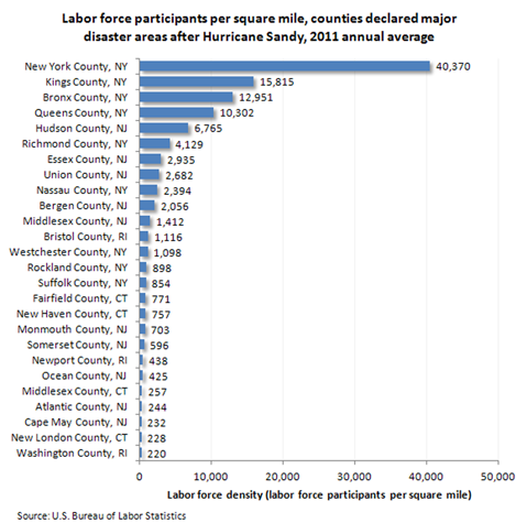
| Area | Labor force participants per square mile |
|---|---|
New York County, NY | 40,370 |
Kings County, NY | 15,815 |
Bronx County, NY | 12,951 |
Queens County, NY | 10,302 |
Hudson County, NJ | 6,765 |
Richmond County, NY | 4,129 |
Essex County, NJ | 2,935 |
Union County, NJ | 2,682 |
Nassau County, NY | 2,394 |
Bergen County, NJ | 2,056 |
Middlesex County, NJ | 1,412 |
Bristol County, RI | 1,116 |
Westchester County, NY | 1,098 |
Rockland County, NY | 898 |
Suffolk County, NY | 854 |
Fairfield County, CT | 771 |
New Haven County, CT | 757 |
Monmouth County, NJ | 703 |
Somerset County, NJ | 596 |
Newport County, RI | 438 |
Ocean County, NJ | 425 |
Middlesex County, CT | 257 |
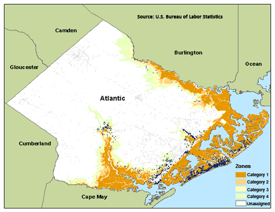
Atlantic County, NJ | 244 |
Cape May County, NJ | 232 |
New London County, CT | 228 |
Washington County, RI | 220 |
| Category | Fourth Quarter 2011 Establishments | October 2011 Employment |
|---|---|---|
1 | 849 | 26,440 |
2 | 959 | 29,278 |
3 | 426 | 8,920 |
4 | 515 | 7,298 |
Unassigned | 3,954 | 61,269 |
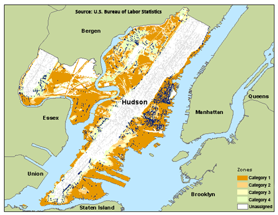
| Category | Fourth Quarter 2011 Establishments | October 2011 Employment |
|---|---|---|
1 | 3,309 | 92,212 |
2 | 1,363 | 24,650 |
3 | 589 | 10,864 |
4 | 798 | 14,878 |
Unassigned | 7,838 | 88,649 |
| Category | Fourth Quarter 2011 Establishments | October 2011 Employment |
|---|---|---|
A | 4,042 | 174,759 |
B | 7,814 | 180,930 |
C | 15,497 | 271,756 |
Unassigned | 93,731 | 1,728,267 |
| Category | Fourth Quarter 2011 Establishments | October 2011 Employment |
|---|---|---|
A | 1,614 | 27,294 |
B | 234 | 1,460 |
C | 1,047 | 9,551 |
Unassigned | 6,001 | 54,240 |
| Category | Fourth Quarter 2011 Establishments | October 2011 Employment |
|---|---|---|
A | 495 | 9,950 |
B | 4,263 | 99,457 |
C | 4,585 | 63,700 |
Unassigned | 36,664 | 334,520 |
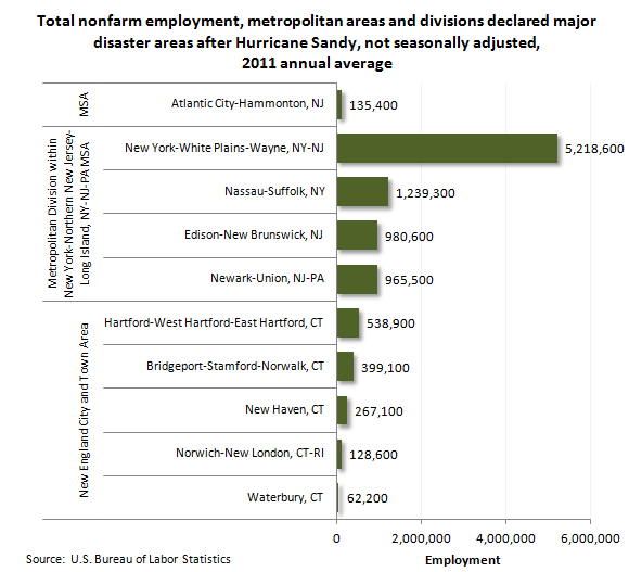
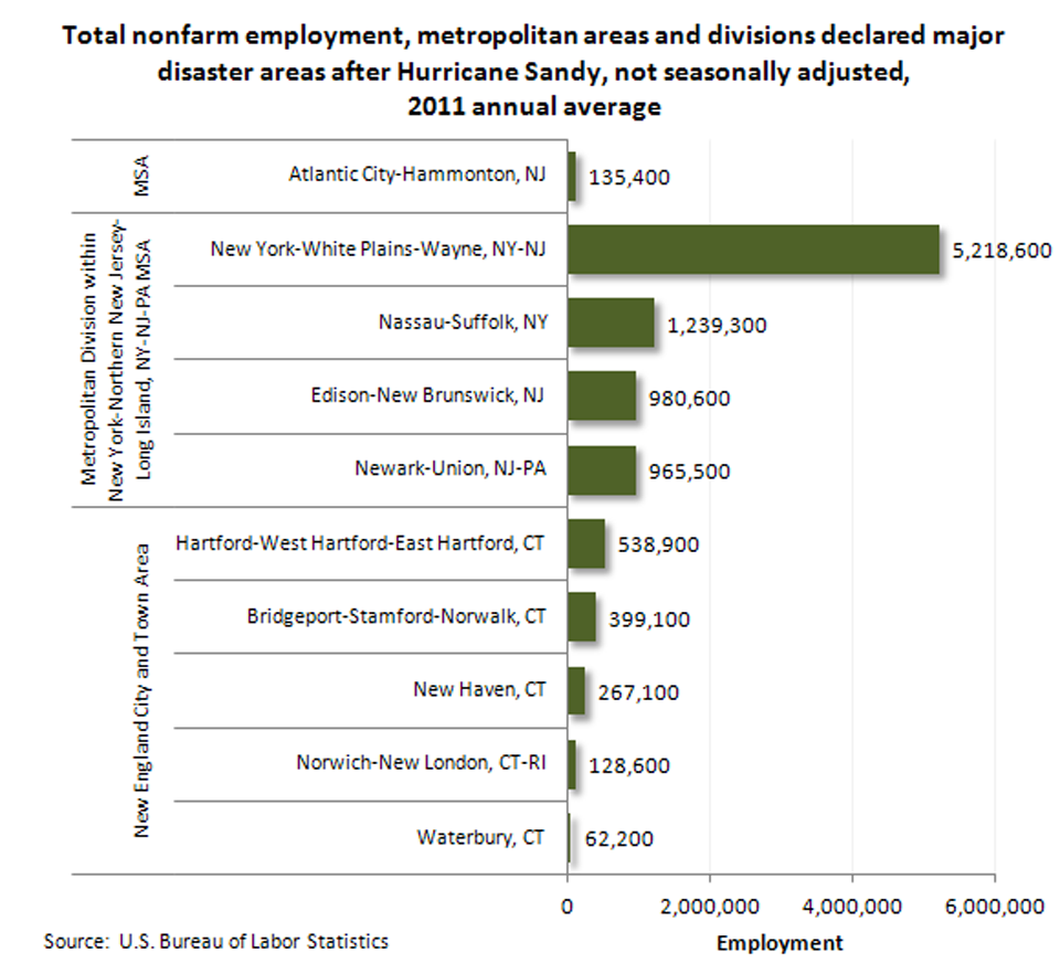
| Area/Division | Total nonfarm employment |
|---|---|
| Metropolitan Statistical Area | |
Atlantic City-Hammonton, NJ | 135,400 |
| Metropolitan Division | |
New York-White Plains-Wayne, NY-NJ | 5,218,600 |
Nassau-Suffolk, NY | 1,239,300 |
Edison-New Brunswick, NJ | 980,600 |
Newark-Union, NJ-PA | 965,500 |
| New England City and Town Area | |
Hartford-West Hartford-East Hartford, CT | 538,900 |
Bridgeport-Stamford-Norwalk, CT | 399,100 |
New Haven, CT | 267,100 |
Norwich-New London, CT-RI | 128,600 |
Waterbury, CT | 62,200 |
Source: State and Metropolitan Area Current Employment Statistics
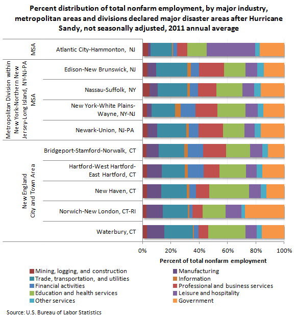
| Industry | Atlantic City-Hammonton, NJ | New York-White Plains-Wayne, NY-NJ Metropolitan Division | Nassau-Suffolk, NY Metropolitan Division | Edison-New Brunswick, NJ Metropolitan Division | Newark-Union, NJ-PA Metropolitan Division | Hartford-West Hartford-East Hartford, CT NECTA | Bridgeport-Stamford-Norwalk, CT NECTA | New Haven, CT NECTA | Norwich-New London, CT-RI NECTA | Waterbury, CT NECTA |
|---|---|---|---|---|---|---|---|---|---|---|
Mining, logging, and construction | 4.1% | 3.2% | 4.9% | 3.6% | 3.4% | 3.2% | 2.8% | 3.4% | 2.9% | 3.4% |
Manufacturing | 1.7% | 3.1% | 5.9% | 6.1% | 7.0% | 10.6% | 8.9% | 9.8% | 11.5% | 12.2% |
Trade, transportation, and utilities | 15.1% | 16.9% | 20.9% | 22.1% | 20.5% | 16.1% | 17.8% | 18.1% | 17.6% | 19.9% |
Information | 0.6% | 3.9% | 2.0% | 2.5% | 1.8% | 2.1% | 2.7% | 1.8% | 1.1% | 1.0% |
Financial activities | 3.0% | 10.4% | 5.7% | 5.7% | 7.0% | 11.5% | 10.6% | 4.6% | 2.4% | 3.2% |
Professional and business services | 7.2% | 15.4% | 12.9% | 17.6% | 17.1% | 11.2% | 16.3% | 9.5% | 7.2% | 6.9% |
Education and health services | 13.8% | 19.6% | 18.6% | 15.1% | 15.1% | 18.4% | 16.8% | 28.1% | 16.2% | 26.0% |
Leisure and hospitality | 34.2% | 8.7% | 8.3% | 8.5% | 7.3% | 7.8% | 8.6% | 8.5% | 11.2% | 7.9% |
Other services | 3.3% | 4.2% | 4.4% | 4.4% | 4.5% | 3.8% | 4.1% | 3.9% | 2.5% | 3.9% |
Government | 17.0% | 14.5% | 16.6% | 14.4% | 16.3% | 15.5% | 11.4% | 12.4% | 27.5% | 15.6% |
Total | 100.0% | 100.0% | 100.0% | 100.0% | 100.0% | 100.0% | 100.0% | 100.0% | 100.0% | 100.0% |
Source: State and Metropolitan Area Current Employment Statistics
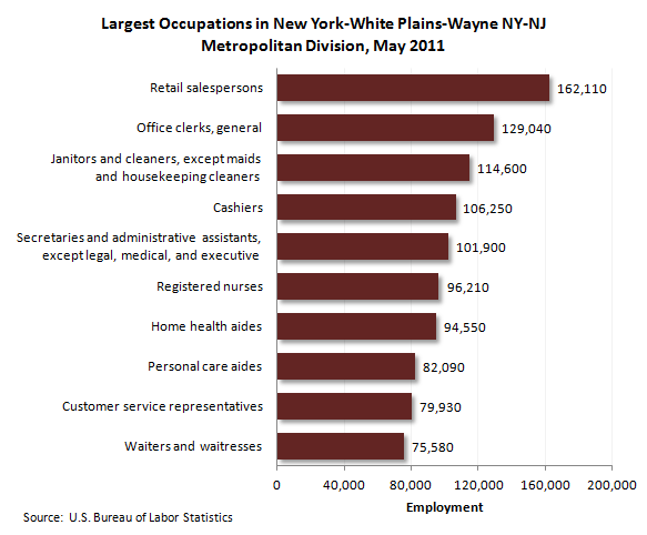
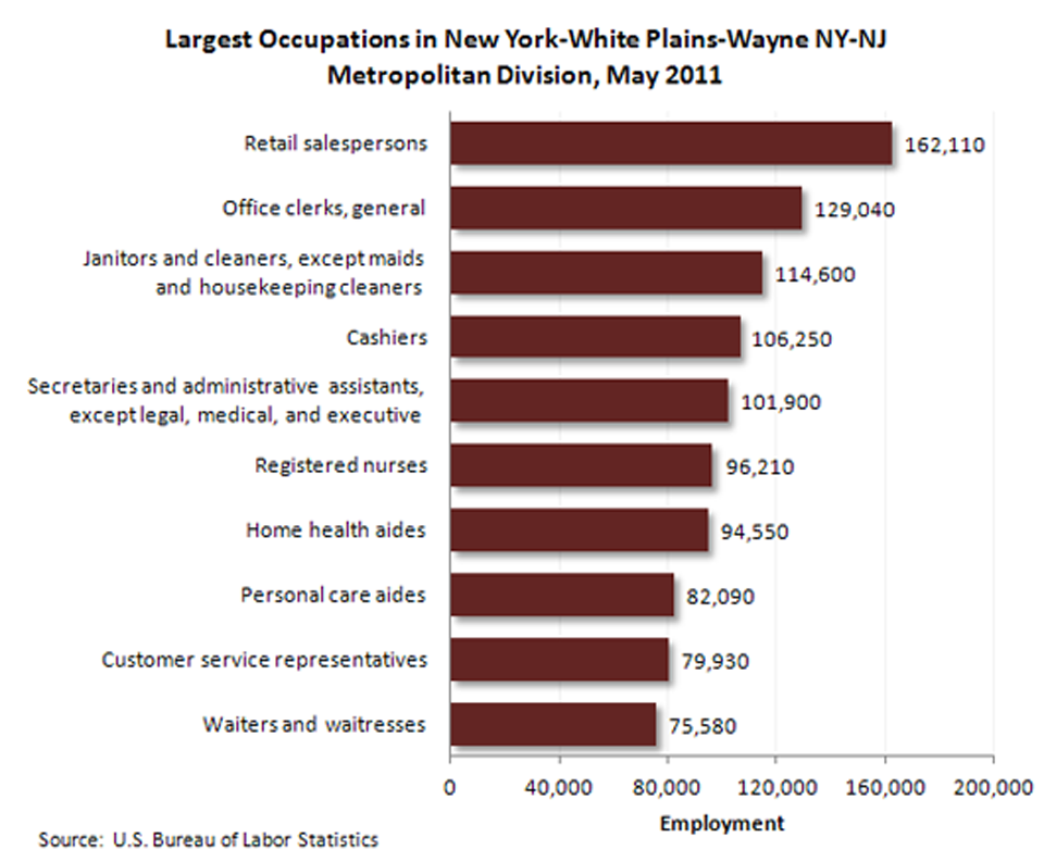
| Occupation | SOC code | Employment |
|---|---|---|
|
Retail salespersons |
41-2031 | 162,110 |
|
Office clerks, general |
43-9061 | 129,040 |
|
Janitors and cleaners, except maids and housekeeping cleaners |
37-2011 | 114,600 |
|
Cashiers |
41-2011 | 106,250 |
|
Secretaries and administrative assistants, except legal, medical, and executive |
43-6014 | 101,900 |
|
Registered nurses |
29-1111 | 96,210 |
|
Home health aides |
31-1011 | 94,550 |
|
Personal care aides |
39-9021 | 82,090 |
|
Customer service representatives |
43-4051 | 79,930 |
|
Waiters and waitresses |
35-3031 | 75,580 |
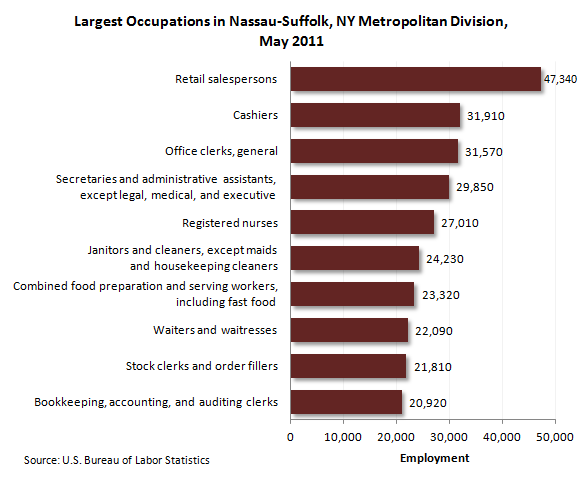
| Occupation | SOC code | Employment |
|---|---|---|
|
Retail salespersons |
41-2031 | 47,340 |
|
Cashiers |
41-2011 | 31,910 |
|
Office clerks, general |
43-9061 | 31,570 |
|
Secretaries and administrative assistants, except legal, medical, and executive |
43-6014 | 29,850 |
|
Registered nurses |
29-1111 | 27,010 |
|
Janitors and cleaners, except maids and housekeeping cleaners |
37-2011 | 24,230 |
|
Combined food preparation and serving workers, including fast food |
35-3021 | 23,320 |
|
Waiters and waitresses |
35-3031 | 22,090 |
|
Stock clerks and order fillers |
43-5081 | 21,810 |
|
Bookkeeping, accounting, and auditing clerks |
43-3031 | 20,920 |
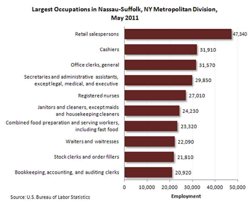
| Occupation | SOC code | Employment |
|---|---|---|
|
Retail salespersons |
41-2031 | 26,500 |
|
Cashiers |
41-2011 | 23,130 |
|
Janitors and cleaners, except maids and housekeeping cleaners |
37-2011 | 22,750 |
|
Registered nurses |
29-1111 | 20,180 |
|
Office clerks, general |
43-9061 | 20,140 |
|
Laborers and freight, stock, and material movers, hand |
53-7062 | 16,780 |
|
Stock clerks and order fillers |
43-5081 | 15,940 |
|
Business operations specialists, all other |
13-1199 | 15,070 |
|
Secretaries and administrative assistants, except legal, medical, and executive |
43-6014 | 14,580 |
|
Combined food preparation and serving workers, including fast food |
35-3021 | 14,270 |
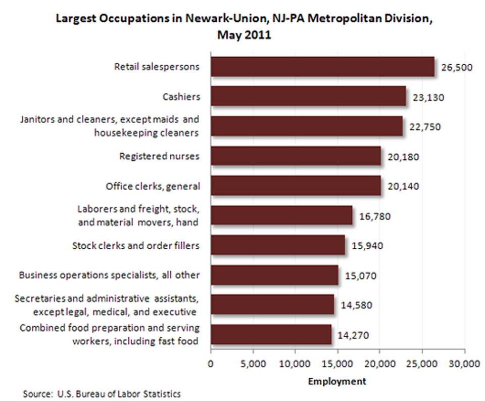
| Occupation | SOC code | Employment |
|---|---|---|
|
Retail salespersons |
41-2031 | 30,690 |
|
Cashiers |
41-2011 | 27,850 |
|
Laborers and freight, stock, and material movers, hand |
53-7062 | 21,560 |
|
Office clerks, general |
43-9061 | 20,700 |
|
Registered nurses |
29-1111 | 18,460 |
|
Stock clerks and order fillers |
43-5081 | 18,180 |
|
Waiters and waitresses |
35-3031 | 15,430 |
|
Secretaries and administrative assistants, except legal, medical, and executive |
43-6014 | 15,230 |
|
Customer service representatives |
43-4051 | 15,210 |
|
Janitors and cleaners, except maids and housekeeping cleaners |
37-2011 | 14,550 |
| Occupation | SOC code | Employment |
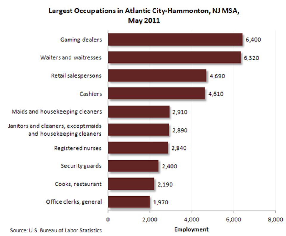
|---|---|---|
|
Gaming dealers |
39-3011 | 6,400 |
|
Waiters and waitresses |
35-3031 | 6,320 |
|
Retail salespersons |
41-2031 | 4,690 |
|
Cashiers |
41-2011 | 4,610 |
|
Maids and housekeeping cleaners |
37-2012 | 2,910 |
|
Janitors and cleaners, except maids and housekeeping cleaners |
37-2011 | 2,890 |
|
Registered nurses |
29-1111 | 2,840 |
|
Security guards |
33-9032 | 2,400 |
|
Cooks, restaurant |
35-2014 | 2,190 |
|
Office clerks, general |
43-9061 | 1,970 |
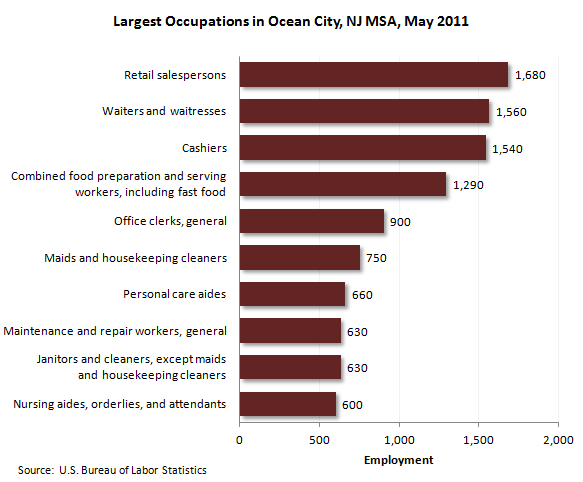
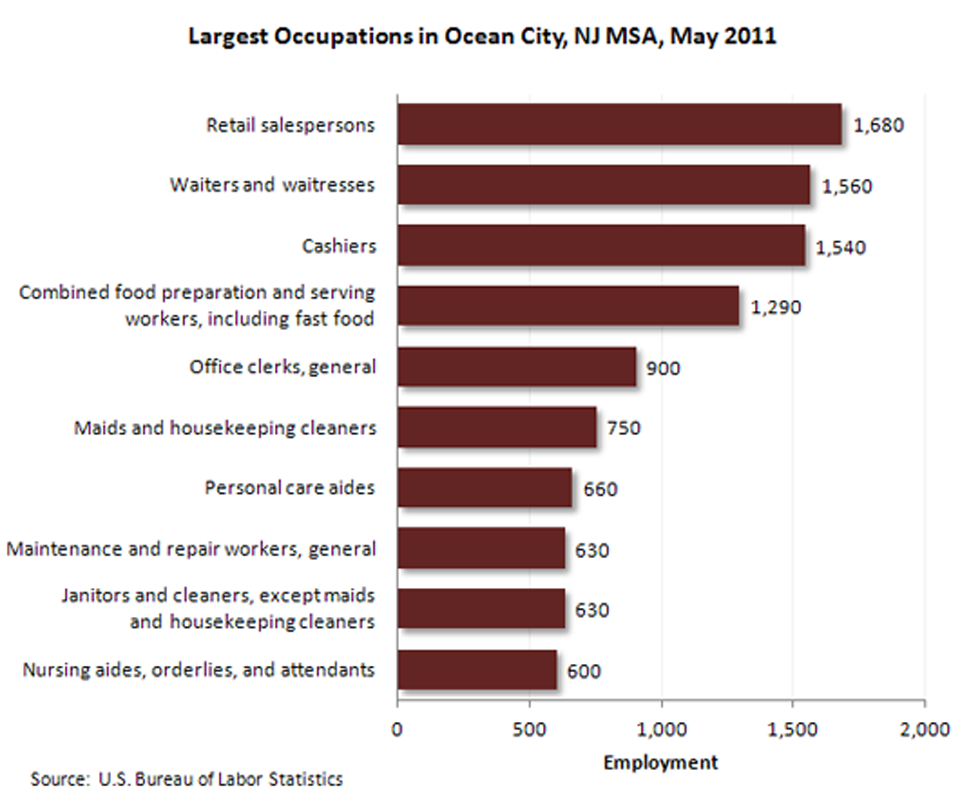
| Occupation | SOC code | Employment |
|---|---|---|
|
Retail salespersons |
41-2031 | 1,680 |
|
Waiters and waitresses |
35-3031 | 1,560 |
|
Cashiers |
41-2011 | 1,540 |
|
Combined food preparation and serving workers, including fast food |
35-3021 | 1,290 |
|
Office clerks, general |
43-9061 | 900 |
|
Maids and housekeeping cleaners |
37-2012 | 750 |
|
Personal care aides |
39-9021 | 660 |
|
Janitors and cleaners, except maids and housekeeping cleaners |
37-2011 | 630 |
|
Maintenance and repair workers, general |
49-9071 | 630 |
|
Nursing aides, orderlies, and attendants |
31-1012 | 600 |
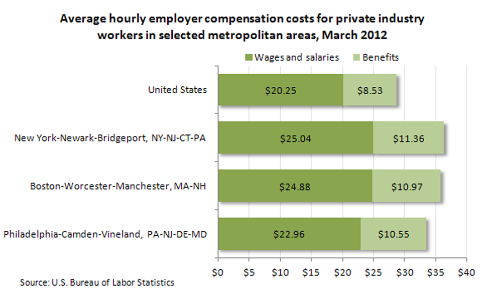
| Metropolitan area | Wages and salaries | Benefits |
|---|---|---|
United States | $20.25 | $8.53 |
New York-Newark-Bridgeport, NY-NJ-CT-PA | 25.04 | 11.36 |
Boston-Worcester-Manchester, MA-NH | 24.88 | 10.97 |
Philadelphia-Camden-Vineland, PA-NJ-DE-MD | 22.96 | 10.55 |
Source: National Compensation Survey